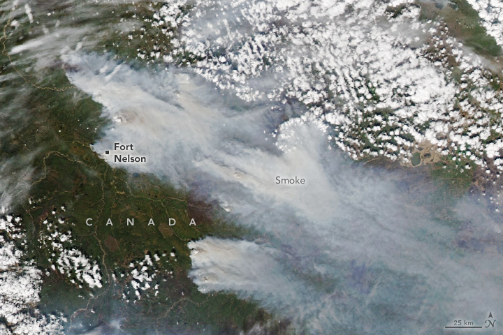
Smoke and Fire in British Columbia
May 13, 2024
Following Canada’s extreme wildland fire season in 2023, unusually early and intense blazes are already raging in 2024. Though wildfire activity does not typically become widespread or intense in British Columbia until several weeks later in the summer, smoke already smothered parts of the western Canadian province in mid-May.
The MODIS (Moderate Resolution Imaging Spectroradiometer) on NASA’s Aqua satellite acquired this image (above) of smoke billowing from several fires around the community of Fort Nelson and streaming east into Alberta on May 11, 2024. Terra and other NASA satellites observed the plume as it was lofted several kilometers into the air and spread eastward. The smoke drifted, at times, into parts of the Upper Midwest and Great Lakes regions of the United States, triggering air quality concerns in several states.
One of the most menacing fires burned southeast of Fort Nelson and a nearby First Nation community, home to a combined 3,400 people. The fire grew rapidly after igniting on May 10, exacerbated by dry conditions and high winds from a passing cold front. Canadian authorities issued evacuation orders for both communities later that day.
“Due to the aggressive and extreme fire behavior, we strongly recommend that people avoid travel in and around Fort Nelson,” said British Columbia’s Wildfire Service Director of Provincial Operations Cliff Chapman in a video update on Facebook. “The fuels are as dry as we have ever seen. The wind is going to be sustained, and it is going to push the fire toward the community,” he added.
To the north of Fort Nelson, several other large fires each charred tens of thousands of hectares. Several of these fires were listed as “holdover” blazes that likely smoldered beneath the snow all winter before reemerging, according to data posted by the British Columbia Wildfire Service. Such fires lingered in vegetation that had been parched by a multi-year drought, classified as extreme by the North American Drought Monitor.
Analysis of May daily intensity & estimated emissions of Canada?? #wildfires shows incredible intensity over the last few days leading to highest May total for British Columbia in 22-year #CopernicusAtmosphere GFAS dataset based on MODIS?? active fire obs https://ads.atmosphere.copernicus.eu/cdsapp#!/dataset/cams-global-fire-emissions-gfas?tab=overview https://twitter.com/m_parrington/status/1789632457517531453
— Mark Parrington (@m_parrington) May 12, 2024
The situation echoes 2023, when intense fires also burned in British Columbia in May. Daily fire intensity and carbon emissions from fires in the province have been unusually high so far in May 2024, according to data shared by Mark Parrington, an atmospheric scientist with the European Centre for Medium-Range Weather Forecasts (ECMWF). In mid-May, carbon emissions from British Columbia’s wildfires passed 5 megatons since the start of the month, the highest May total for the province in 22 years.
Parrington tracks fire emissions for the Copernicus Atmosphere Monitoring Service (CAMS) using data from NASA. CAMS provides estimates of near-real-time wildfire emissions using its Global Fire Assimilation System (GFAS), which aggregates MODIS observations of fires made by NASA’s Aqua and Terra satellites.
NASA Earth Observatory image by Wanmei Liang, using MODIS data from NASA EOSDIS LANCE and GIBS/Worldview. Story by Adam Voiland, with information from Hiren Jethva and Eli Orland.
