A Winter Haze Over China
Jan 6, 2022
While levels of air pollution over China have decreased significantly in recent years, outbreaks of air pollution still regularly darken skies in some areas.
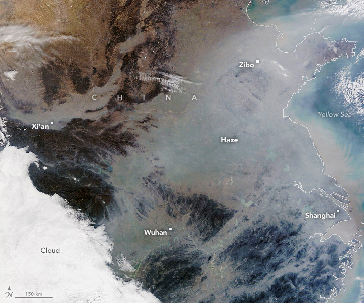
The Moderate Resolution Imaging Spectroradiometer (MODIS) on NASA’s Terra satellite acquired this natural-color image of northeastern China on January 3, 2022. A pall of gray haze hangs over valleys and other low-lying areas, partially obscuring cities, farmland, lakes, and other features that would normally be more visible. The bright areas on the lower left of the image are clouds.
On the day that the image was acquired, several ground-based sensors in the region reported levels of fine particulate matter (PM2.5) in the very unhealthy and hazardous range, according to data published by The World Air Quality Project. That means PM2.5 levels were several times higher than the World Health Organization’s recommended limit of an average of 15 micrograms averaged over a day.
Outbreaks of haze generally occur during the winter because of temperature inversions. Air normally cools with altitude, but during an inversion warm air settles above a layer of cool air near the surface. The warm air acts like a lid and traps pollutants near the surface, especially in basins and valleys. Common sources of pollution in the winter include coal and wood burning for heat, industrial activity, and vehicle emissions. Smoke from fires and dust storms can also contribute to poor air quality.
One likely component of the haze in this image is nitrate particles. According to one recent analysis led by Harvard University researchers, levels of nitrates have remained stubbornly high over China in recent years even as emission controls have significantly reduced concentrations of other types of particles that contribute to PM2.5. “Nitrate is now the principal component of Beijing winter haze pollution, contributing to 30-40 percent of PM2.5M mass during winter haze days,” the authors wrote. “There is an urgent need to better understand why nitrate is not decreasing.”
NASA Earth Observatory image by Lauren Dauphin, using MODIS data from NASA EOSDIS LANCE and GIBS/Worldview. Story by Adam Voiland.
