Pacific Tic-Tac-Toe
Dec 29, 2021
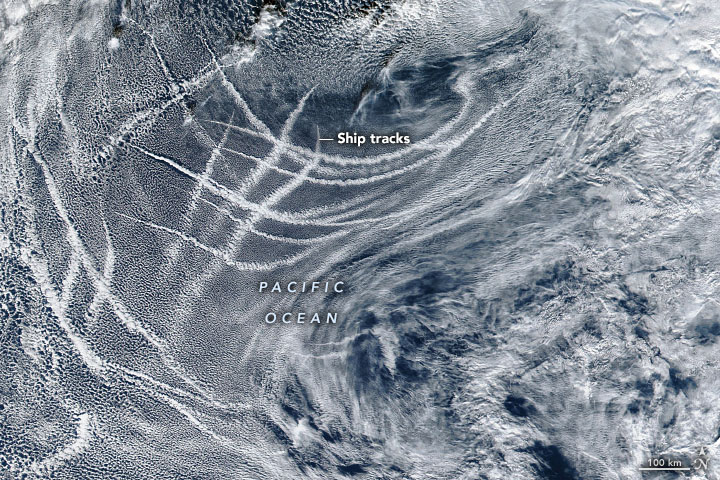
The arrangement of lines in this image might look like an oceanic game of tic-tac-toe, but in fact, the grid can be explained by a relatively common atmospheric feature. Ship tracks are long, narrow clouds that form in the sky over the ocean when water vapor condenses around tiny particles in ship exhaust.
The Visible Infrared Imaging Radiometer Suite (VIIRS) on the Suomi-NPP satellite acquired this image of ship tracks on December 7, 2021. On that day, the tracks revealed several shipping lanes intersecting in the waters off the Pacific coast of North America.
Trails of aerosol pollution from ships are present with or without the clouds. But the presence of these numerous tiny particles can become more apparent in natural-color images when the particles interact with low-level clouds and cause them to brighten. This happens because aerosols allow more and smaller cloud droplets to form, providing more surfaces to reflect light.
Scientists have been studying the phenomenon for decades, teasing out the complex interactions between aerosols and clouds to decipher what those interactions mean for climate change. For instance, scientists want to know the extent that ship tracks can lead to cooling across the planet.
In recent years, scientists have been using machine learning to help identify ship tracks—some of which can go undetected by human eyes—and to classify various cloud types around the planet. The technique is helping to grow the collection of cloud images available for scientific study.
NASA Earth Observatory image by Joshua Stevens, using VIIRS data from NASA EOSDIS LANCE, GIBS/Worldview, and the Suomi National Polar-orbiting Partnership. Story by Kathryn Hansen.
